Please Note:
These pages contain information based on the United States Federal Department of Transportation's "Manual on Uniform Traffic Control Devices" (MUTCD). Some state signage and markings may vary slightly from the national standard. Since driving may include going through different states, we have only included the "standards," and not all the variances.
The shape and color of a sign offers you a clue about the information contained on the sign. Here are the common shapes used:
An 8-sided red STOP sign indicates that you must make a full stop whenever you see this sign. Stop at the white limit line (a wide white line painted on the street) or before entering the crosswalk. If a limit line or crosswalk is not painted on the street, stop before entering the intersection. Check traffic in all directions before proceeding.
A 3-sided red YIELD sign indicates that you must slow down and be ready to stop, if necessary, to let any vehicle, bicyclist, or pedestrian pass before you proceed. Yield means to give the right-of-way to traffic on the road you are entering or crossing.
A square red and white regulatory sign may have different instructions. For example, the DO NOT ENTER sign means do not enter a road or off ramp where the sign is posted (usually on a freeway off ramp). The WRONG WAY sign may or may not be posted with the DO NOT ENTER sign. If you see one or both of these signs, drive to the side of the road and stop. You are going against traffic. When safe, back out or turn around and return to the road you were on. At night if you are going the wrong way, the road reflectors will shine red in your headlights.
A sign that has a red circle with a red line through it always indicates “NO.” The picture inside the circle shows what you cannot do. The sign may be shown with or without words.
A yellow and black circular sign indicates that you are approaching a railroad crossing.
An X-shaped sign with a white background that states RAILROAD CROSSING indicates that you must look, listen, slow down, and prepare to stop, if necessary. Let any trains pass before you proceed.
A 5-sided sign indicates that you are near a school. Stop if children are in the crosswalk.
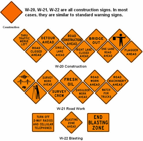
A 4-sided diamond-shaped sign warns you of specific road conditions and dangers ahead. Many warning signs are diamond shaped.
A white rectangular sign indicates that you must obey important rules.
Some warning signs have a fluorescent yellow-green background. These signs warn of conditions related to pedestrians, bicyclists, schools, playgrounds, school buses, and school passenger loading zones. Obey all warning signs regardless of their shape or color.
MUTCD Standard
Warning signs call attention to unexpected conditions on or adjacent to a highway or street and to situations that might not be readily apparent to road users. Warning signs alert road users to conditions that might call for a reduction of speed or an action in the interest of safety and efficient traffic operations.
Note:
When the safe, navigable speed is LESS than 35 mph, a curvature in the road is called a "TURN;" if GREATER than 35 mph, it is called a "CURVE."

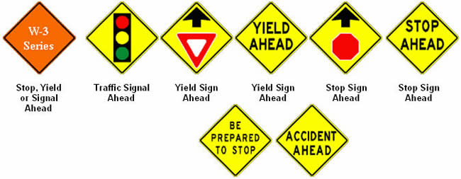


Grade is the amount of rise or fall per 100 feet of roadway. A 7% grade means that the roadway hill goes downward 7 feet for every 100 feet forward (or vice-versa for uphill).
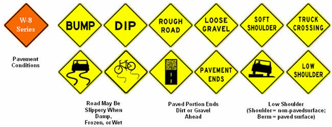
These signs warn of possible slow or stopped traffic ahead, due to the possibility of a train on the tracks. Turning traffic may be backed up onto the main roadway.
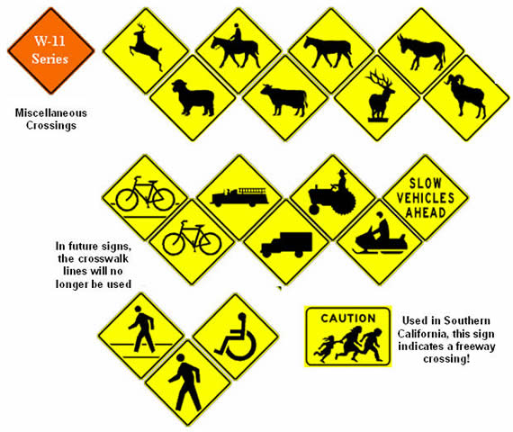
The Share the Road plaque is placed beneath any of the W-11 Series signs to warn drivers of the possibility of slower moving vehicles on the roadway, in addition to just crossing the road.
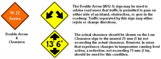
The advisory speed plate is intended for use to supplement warning signs. The speed shown shall be a multiple of 5 miles per hour. The plate may be used in conjunction with any standard yellow warning sign to indicate the maximum recommended speed around a curve or through a hazardous location.
The Exit or Ramp signs are intended for advising drivers of the maximum recommended speed on a ramp. The sign should be posted along the deceleration lane or along the ramp so that it is visible in time for the driver to make a safe slowing and exiting maneuver.
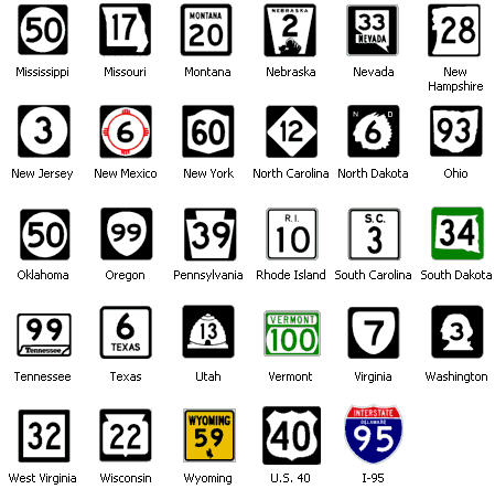
Most State Route markers carry either a name or a symbol that is symbolic to that state. Some States use a map outline of their state, some use a simple circle or square. Other may use a symbol, such as California. The rounded triangle represents a miner's spade, in memory of the "forty-niners" and the Gold Rush.
Kansas, the "Sunflower State" uses a sunflower on their state signs, while Pennsylvania, the "Keystone State" uses the keystone for an arch as their symbol.
A close look at the map above will show that the seemingly random red lines actually have a pattern. Let's start in California. Disregard Route 101.
Notice that the first interstate you see is I-5, which runs south-to-north through the state. At the bottom of the state is I-10, which runs in a west-to-east direction, through the bottom of the state. Now look over to the New England states. Notice that all the interstates are odd-numbered, and they all run in a south-to-north direction.
The Interstate Numbering System consists of even and odd numbers. EVEN numbered routes run in an east-to-west direction, while ODD numbered routes run south-to-north. In addition, the EVEN numbers get bigger as you move further NORTH, and the ODD numbers get bigger as you move EAST.
The standard interstate routes will always have one or two digits (I-5 or I-70) and will appear on a blue-and-red shield. Then there are SPURS and LOOPS. These signs have 3 digits (I-495). As a GENERAL rule, if the first digit is EVEN, the route is an Interstate Loop, which means it usually goes around a city or urban area and then reconnects to the Interstate again, with an Interstate at both ends. If the first number is ODD, then the SPUR route LEAVES an Interstate, and connects with a major highway, or ends (for example, at another street).
As a side note, to dispel a consistent rumor, there is NO provision in the Federal Highway Act that says "one-out-of-seven" miles of an Interstate must be straight and wide enough for military defense airplanes to land.
If an interstate splits off and enters a city business center directly, or goes immediately around it, a special marker called a BUSINESS LOOP or SPUR is used.
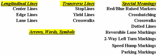
Markings on highways have important functions in providing guidance and information for the road user. Major marking types include:
In some cases, markings are used to supplement other traffic control devices such as signs, signals and other markings. In other instances, markings are used alone to effectively convey regulations, guidance, or warnings in ways not obtainable by the use of other devices.
Pavement markings can enhance roadway delineation with the addition of audible and tactile features such as:
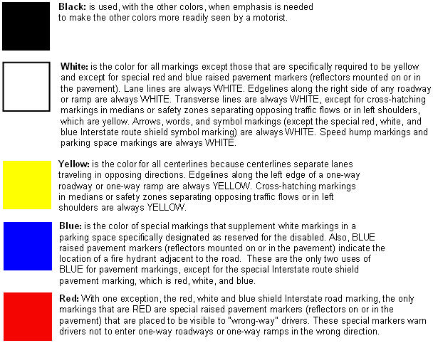
A broken (dashed) yellow centerline on the left side of a travel lane indicates passing is allowed in that direction.
A solid yellow centerline on the left side of a travel lane indicates passing is prohibited in that direction.
A centerline might not be in the physical center of the road, as shown in the illustrations.
Along a one-way ramp, one-way street, or a one-way roadway that is one half of a divided highway, YELLOW lines mark the left edge of pavement or the boundary between a travel lane and an adjacent left shoulder.
A lane that is operated in different directions at different times of the day, such as a reversible lane system, is designated by a DOUBLE BROKEN (dashed) YELLOW line on both sides of the lane. These markings supplement signs or overhead signals that tell road users which lanes are available for use at different days and times.
Many two-way undivided roads in urbanized areas have a center lane that is for shared use by vehicles making left turns in both directions. This type of special lane is called a Two-Way Left-Turn Lane. Both sides of the Two-Way Left Turn Lane are marked with a double line consisting of a SOLID YELLOW line and BROKEN (dashed) YELLOW line. The SOLID line is closest to the adjacent travel lane, while the BROKEN (dashed) line is closest to the Two-Way Left-Turn Lane.
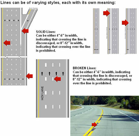
White lines, longitudinal (parallel to traffic), are used to indicate lanes edges. A dashed white line marks a lane that can be crossed over, while a solid white line indicates a line where crossing over is either discouraged or prohibited.
A solid white line, on the right edge of the road, is used to set the limit of the "vehicular portion of the roadway", which cannot be crossed, except in the case of a BIKE LANE, where a right turn is going to be made. California law permits a driver to move into the bike lane, up to 200 feet prior to making a right turn.
At an exit ramp or street, the solid white line may join with the main highway edge line to form a "GORE" area, which is considered to be a safety zone, where vehicular traffic movement is prohibited.
White transverse lanes lines (perpendicular to traffic flow) are used to indicate stopping, yielding, and cautionary areas, where traffic is controlled for one reason or another.
In the image, the end of the YELLOW line coincides with the thicker white transverse line where stopping is mandatory. This is called the STOP LINE, or more commonly, the LIMIT LINE. All traffic must stop with the complete vehicle behind this line.
Where there is no limit line, the double white transverse lines indicate a crosswalk, and traffic must stop completely behind the first crosswalk line (when stopping is mandated by a light or sign).
Crosswalks may be marked in various styles. The traditional two white lines (yellow in a school zone) is the most common style. When a higher degree of visibility is required, diagonal or perpendicular lines may be used.
Some intersections, especially in downtown areas, may allow for DIAGONAL crosswalks also, where the pedestrian is permitted to cross through the middle of the intersection, corner-to-corner., as shown in the bottom picture at the left.
Many suburban areas, especially, are using "traffic calming" measures, to slow traffic without actually stopping it. One of the most common is the "SPEED HUMP". To warn drivers of the speed hump, white transverse lines, of decreasing width, are evenly spaced 100 feet prior to the center of the hump.
Another line used to slow traffic is the newer YIELD LINE. Instead of the usual LIMIT LINE, a transverse line, consisting of white triangles, is used to indicate where traffic should slow down (and stop if necessary) when yielding to vehicle and pedestrian traffic.
Increasingly common, TRAFFIC CIRCLES, or ROUNDABOUTS, are also being used to control the speed of traffic. These vary in size, from smaller, garden-plot sized, to larger, multi-lane ones, as shown in the image.
Notice that various lines are used throughout to indicate traffic flow, stops, yields, and lanes through the circle.
Curb colors are used to indicate parking restrictions.
A RED curb indicates that ALL parking, stopping, or standing (see our SIGNS page for definitions) is prohibited. The sole exception is for transit buses, which may stop ONLY at a signed BUS STOP.
A BLUE curb indicates that UNLIMITED parking is permitted, providing the vehicle has either a HANDICAPPED placard hanging from the rear-view mirror, or a HANDICAPPED license plate.
A YELLOW curb is used to indicate parking, stopping, or standing is permitted, for delivery or drop-off, usually for commercial purposes.
A GREEN curb indicates that parking is permitted, but only for a period of time. The permissive times are either placed on an adjacent sign or painted directly onto the curb itself.
A WHITE curb is similar to the YELLOW curb, but is a general-purpose curb, for dropping off passengers, mail, etc. As a general rule, the driver must remain in the vehicle.
If a curb is unpainted, then parking is permitted, with no restrictions, unless a sign is used to indicate otherwise.
You will now answer 5 questions to test what you learned during this lesson. You must answer all questions correctly to receive completion credit for this lesson. You may answer the questions as many times as necessary to get them right.
You should review the lesson material if you don't do well on the quiz.

*Check with your California insurance agent for eligibility details. Every licensed California Driver must have auto insurance to drive a vehicle in California. Proof of insurance must be provided to the California DMV when you obtain your drivers license (not your learners permit).
